
Geography Optional PYQs Topic-wise for UPSC Mains (1995–2026) are listed below unit by unit, in the order of the official syllabus – 1249 questions in all. Click any unit to open all its previous year questions, arranged topic-wise with the latest first.
Want full papers instead? Open the Geography Optional year-wise question papers for Paper I and Paper II.
Paper I
Principles of Geography: Physical Geography
| Unit | Topic (click to open PYQs) | Sub-topics | Questions | Link |
|---|---|---|---|---|
| 1 | Geomorphology | 9 | 87 | Click here → |
| 2 | Climatology | 8 | 81 | Click here → |
| 3 | Oceanography | 8 | 60 | Click here → |
| 4 | Biogeography | 5 | 49 | Click here → |
| 5 | Environmental Geography | 6 | 60 | Click here → |
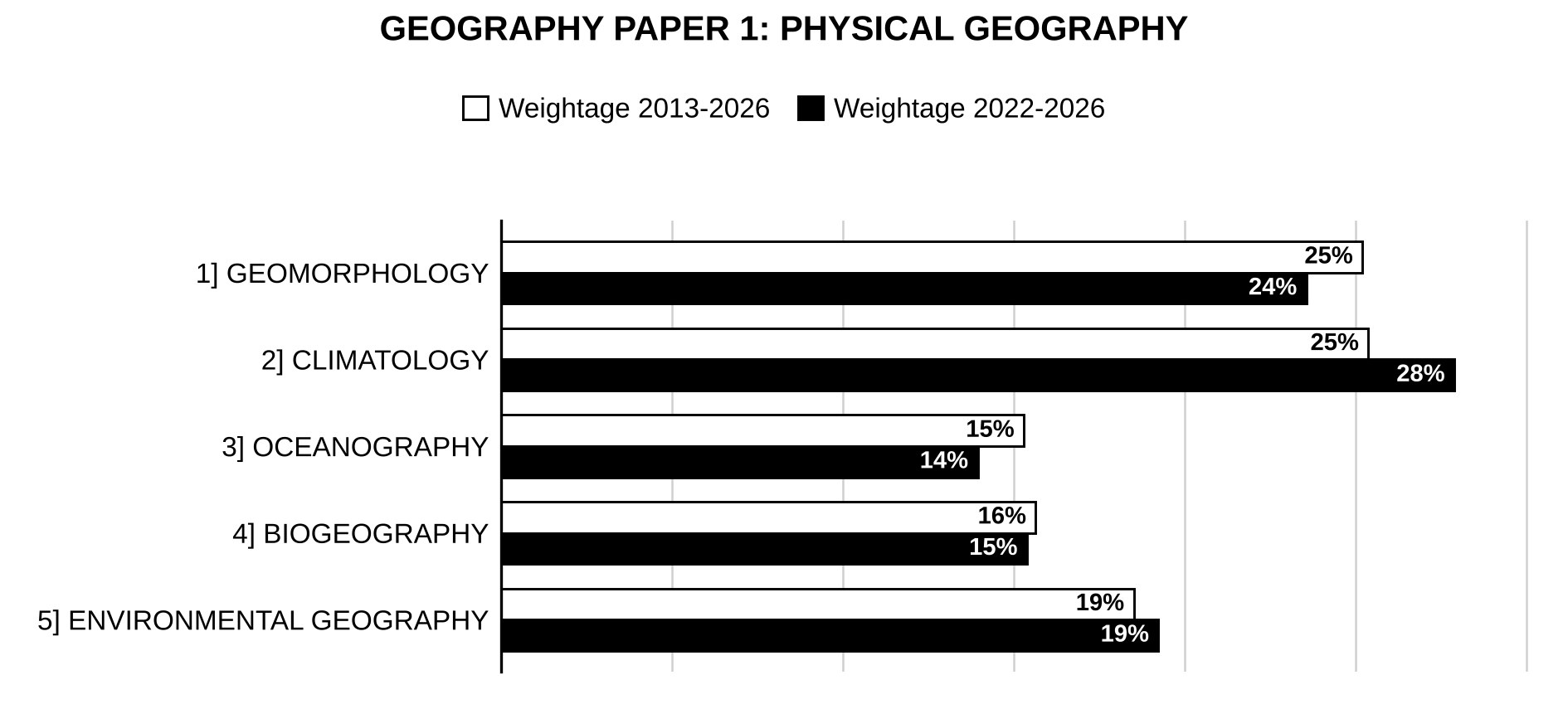
Trend: Climatology (25% of Physical Geography marks over 2013–2026, rising to 28% in 2022–2026) and Geomorphology (25%) carry half the marks of this part. Environmental Geography is steady at about 19%, while Biogeography (16%) and Oceanography (15%, easing to 14%) carry the rest. The most-asked topics are factors in the distribution of plants and animals (biomes and realms), geomorphic cycles, channels and slopes, environmental degradation and management, atmospheric circulation and climate change; air masses, fronts and cyclones, and global and regional ecological imbalances have come up strongly in 2022–2026.
Principles of Geography: Human Geography
| Unit | Topic (click to open PYQs) | Sub-topics | Questions | Link |
|---|---|---|---|---|
| 6 | Perspectives in Human Geography | 6 | 68 | Click here → |
| 7 | Economic Geography | 6 | 62 | Click here → |
| 8 | Population and Settlement Geography | 8 | 79 | Click here → |
| 9 | Regional Planning | 4 | 31 | Click here → |
| 10 | Models, Theories and Laws in Human Geography | 9 | 62 | Click here → |
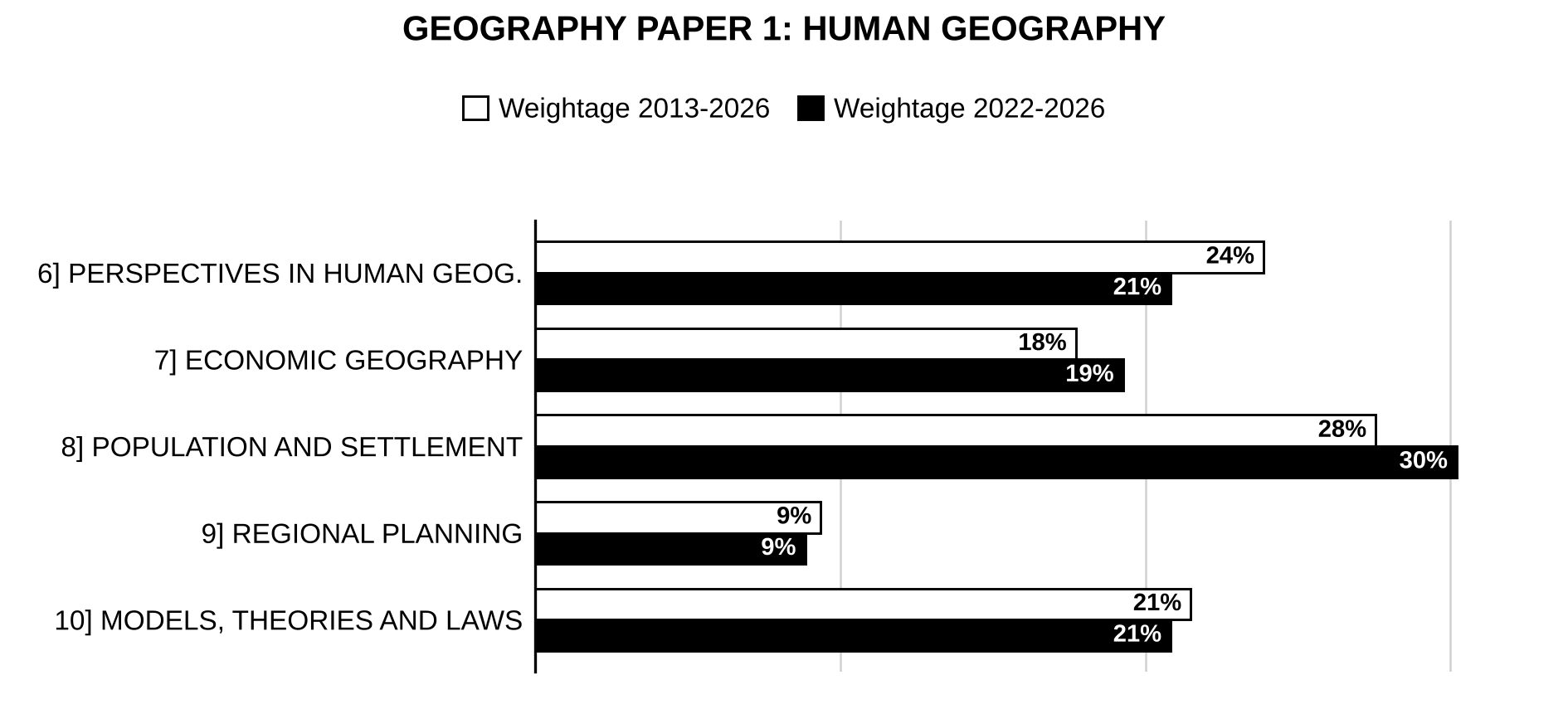
Trend: Population and Settlement Geography is the heaviest unit of Human Geography (28% over 2013–2026, 30% in the last five years), followed by Perspectives in Human Geography (24%, easing to 21%) and Models, Theories and Laws (21%). Economic Geography has risen (18% → 19%), while Regional Planning stays the lightest (about 9%). The single most-asked topic is radical, behavioural, humanistic and welfare approaches; in 2022–2026 migration, urban hierarchy and morphology (primate city, rank-size), problems of urbanisation, world agriculture and resources lead.

Preparing for Prelims too?
Our UPSC Prelims Topic-wise PYQ eBook covers every Prelims question with detailed explanations, so you can see exactly where UPSC asks from.
View the BookDownload Free SamplePaper II
| Unit | Topic (click to open PYQs) | Sub-topics | Questions | Link |
|---|---|---|---|---|
| 1 | Physical Setting | 6 | 77 | Click here → |
| 2 | Resources | 3 | 52 | Click here → |
| 3 | Agriculture | 8 | 59 | Click here → |
| 4 | Industry | 5 | 64 | Click here → |
| 5 | Transport, Communication and Trade | 3 | 43 | Click here → |
| 6 | Cultural Setting | 6 | 61 | Click here → |
| 7 | Settlements | 4 | 58 | Click here → |
| 8 | Regional Development and Planning | 6 | 57 | Click here → |
| 9 | Political Aspects | 4 | 57 | Click here → |
| 10 | Contemporary Issues | 9 | 82 | Click here → |
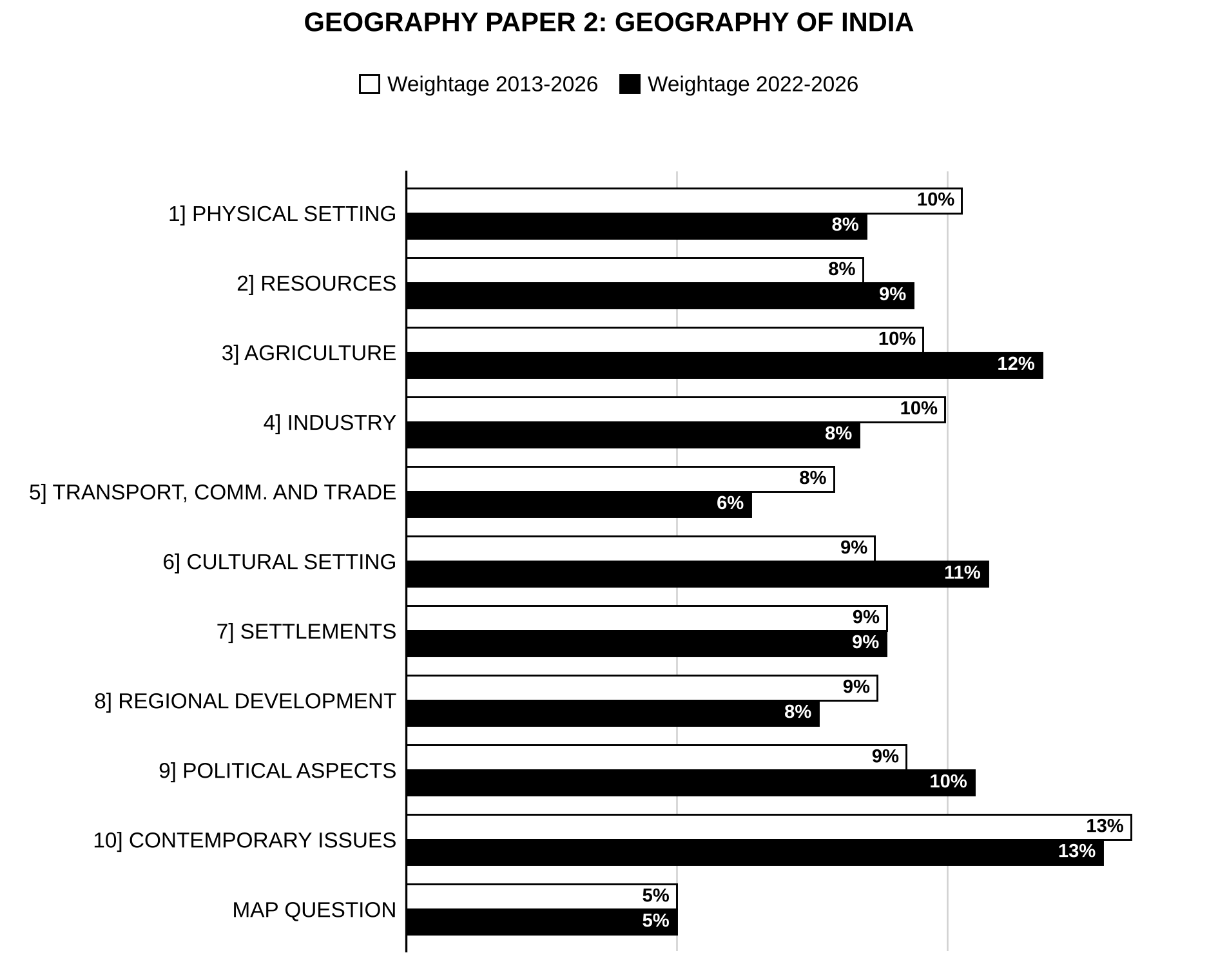
Trend: Marks in Paper 2 are spread across all ten units, with Contemporary Issues the heaviest (13%) and the compulsory map exercise a steady 5%. In the last five years Agriculture (10% → 12%), Cultural Setting (9% → 11%) and Political Aspects (9% → 10.5%) have gained, while Physical Setting, Industry and Transport have eased. The most-asked topics are India’s role in world affairs and the geopolitics of South Asia and the Indian Ocean, cropping pattern and productivity, location of industries, energy and minerals, slums and urban problems, hazards and pollution.
More questions
Map questions – 47 questions
Other questions (outside the present syllabus) – 2 questions
How this collection is organised
Considering the changing exam pattern and syllabus over three decades, we felt it necessary to declare some practices we’ve adopted in this collection.
A few questions fall outside the present syllabus of their paper (for example Al Biruni’s contribution to geography in Paper 1, or innovation diffusion in Paper 2). We’ve kept them under “Other Questions (Outside the Present Syllabus)” at the end of the paper concerned.
Map questions are kept together under “Map Questions” at the end of each paper, with the places to be marked listed after the question. The whole map exercise carries one question code. Up to 1999 Paper 1 offered an India list or a world list; from 2000 to 2009 Paper 1 had a world map, and Paper 2 has always carried the India map.
Some questions cover more than one topic. We’ve kept such questions in each topic of relevance. Topics that the syllabus does not name separately are placed in the nearest topic: for example, weathering and landforms under factors controlling landform development; biomes and zoogeographic realms under distribution of plants and animals; determinism and possibilism under environmentalism; river water disputes under inter-State issues; and coral reefs of India under biotic and marine resources.
Units are numbered as in the official syllabus, except that the Human Geography units of Paper 1 (numbered 1–5 in the notification) are numbered 6–10 here: Paper 1 – units 1–5 (Physical Geography) and 6–10 (Human Geography); Paper 2 – units 1–10 (Geography of India). Where a unit has many questions, they are further divided by the topics of that unit.
Graphs at the start of each part (Physical Geography, Human Geography, Geography of India) show the weightage of every unit in that part, and graphs for the heaviest units show the weightage of their topics. Weightage is the share of marks asked from a unit or topic, compared for 2013–2026 (white bars) and the last five years, 2022–2026 (black bars). A question placed under two topics has its marks split equally between them.
Each of the topicwise question is suffixed by a question code like this [2024/10m/150w/5e]. This code indicates a) year in which the question was asked, b) maximum marks the question carried, c) prescribed word limit and, d) the question number in actual paper, in given order. Where UPSC prescribed no word limit, that field is skipped.
Until 2012, each paper carried 300 marks (60 marks per question); since 2013 each paper carries 250 marks. For 1995–1999 the marks were not printed in available sources, so codes follow the standard pattern of those papers: 20 marks for each part of a short-notes question (any three) and 60 marks for every other question, including the map question.
The 1999 Paper 2 has not been found in any source (all sources repeat the 1998 paper under 1999). Nine of its questions, recovered from dated topic-wise lists, carry the question numbers R1–R9 in their codes.
Where a part of a short-answer question is a statement without a directive word, it is shown as “Comment on: …”, as the question paper asks. The wording of the questions is otherwise as printed.
Spotted an error? Use the “Report an Error” box at the end of any page – we review every report and update the page.

Strengthen your GS papers
Our UPSC Mains Topic-wise & Year-wise PYQ eBook (2013–2026) maps every GS question to the syllabus, so you know what UPSC asks and how often.
View the BookDownload Free SampleLast updated: 30 October 2026