
Here are all 154 Geomorphology and Remote Sensing questions asked in UPSC Geology Optional Paper I from 1995 to 2026, arranged under the 6 topics of the official syllabus. Within each topic the latest questions come first.
Each question ends with a code such as [2024/15m/3b] – the year, the marks, the word limit (where UPSC set one) and the question number in the paper.
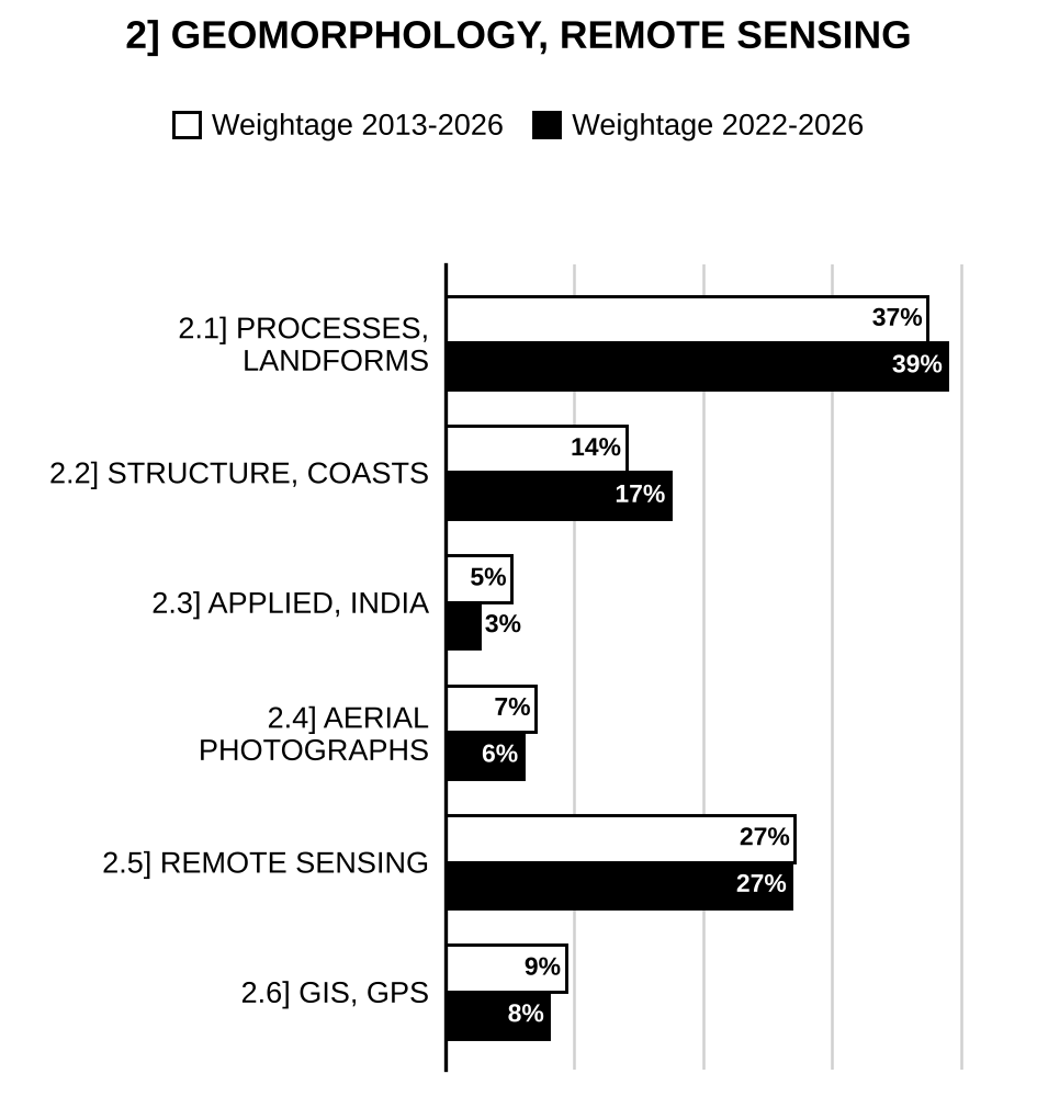
2.1] Geomorphic processes and landforms
55 questions
Discuss the statement giving suitable examples. “Physical weathering adds to the effectiveness of Chemical weathering”. [2025/10m/150w/1d]
Geomorphic diversity is controlled by a number of endogenic and exogenic processes. Discuss this statement. [2025/15m/2b]
Discuss the process of soil formation. [2024/10m/150w/1d]
Discuss in detail the ideas of geomorphic cycle proposed by Davis and Penck. [2024/15m/2b]
Discuss in detail, with diagrams, the landforms and features resulting from deposition by rivers. [2024/20m/3a]
Describe the physical and chemical weathering processes. [2023/10m/150w/1b]
Elucidate the types of glacier and illustrate the erosional and depositional features produced by the valley-glaciers. [2023/20m/3a]
Illustrate and describe any five types of drainage pattern and give an account of the factors that influence drainage pattern development. [2022/10m/150w/1c]
Describe the geomorphic landforms produced by structural, weathering, erosional and depositional processes. Give four examples of each process. [2022/20m/3a]
What are the weathering stages of soil formation? Discuss the active and passive factors of soil formation. [2022/15m/4c]
Discuss the geomorphic processes. Cite any four aggradational and four degradational land forms associated with fluvial processes. [2021/15m/2b]
What are the fundamental concepts used in Geomorphological studies? Explain the concept “little of the earth’s topography is older than Tertiary and most of it no older than Pleistocene? [2021/20m/3a]
Define drainage pattern, Drainage texture and Drainage anomaly. Also give their general classification. Discuss the significance of those in geological interpretation of aerial photos and satellite images. [2021/15m/4c]
Briefly describe two diagnostic landforms each of hot-arid and cold-arid climate. [2020/10m/150w/1c]
Describe three main controlling factors of soil formation. How does the modern soil differ from the palaeosoil? [2020/15m/4c]
What are the characteristics of glacio-fluvial deposits? Discuss five glacio-fluvial depositional landforms with neat diagram. [2019/10m/150w/1b]
What is meant by the term ‘drainage pattern’? Draw neat diagrams and illustrate four different drainage patterns, and discuss their significance with respect to lithology and structure. [2019/15m/4b]
Describe a desert and discuss how a desert is classified. Discuss the morphology of a dune and conditions favouring formation of different dune types. [2018/20m/2a]
Origin of Karst topography. [2017/10m/150w/1b]
What are river terraces? Discuss their geological significance. [2017/15m/3a]
Explain the concept of Davis on geomorphic cycles. [2016/15m/2a]
What are valley glaciers? Describe the major landforms produced due to glacial erosion. [2016/15m/3b]
Using neat diagrams, classify and describe drainage patterns. [2015/10m/150w/1c]
Describe various fluvial landforms formed in response to rejuvenation. [2015/15m/3c]
Describe the erosional and depositional landforms produced by wind. Give Indian examples. [2014/20m/2a]
Describe the variation of slope along the longitudinal river profile with a brief note on major landforms produced along the length of a river. [2014/20m/4a]
Aeolian landforms. [2013/10m/150w/1c]
Types of weathering. [2013/20m/4a]
Davis cycle of erosion. [2012/12m/150w/1b]
Soil groups of India. [2010/15m/150w/5d]
Weathering and mass wasting. [2007/20m/200w/1b]
Geomorphic cycles and their interpretation. [2005/20m/200w/1b]
Fluvial Landforms. [2005/30m/3a]
Two major landforms. [2004/20m/200w/1b]
The basic concepts of Geomorphology. [2004/30m/3a]
How do structure, climate, topography and vegetation influence rocks in nature? [2003/20m/1a]
Which earth processes control the drainage geomorphology? [2001/20m/200w/1b]
What do you understand by Geomorphic cycles? [2000/20m/200w/1c]
Fluvial landforms. [2000/15m/4c]
Landforms of Glaciated mountains. [1999/12m/4b]
River-piracy. [1999/12m/4d]
Barchans and Loess. [1999/12m/4e]
Moraines. [1998/12m/3a]
Canyons and Gorges. [1998/12m/3c]
Slump. [1998/12m/3e]
Superimposed drainage. [1997/15m/3b]
Geomorphic processes and cycles. [1997/15m/3c]
Describe the landforms of the glacial region. [1997/60m/4]
Stalactites and Stalagmites. [1996/12m/3a]
Antecedent drainage. [1996/12m/3b]
Piedmont glacier. [1996/12m/3c]
Yardangs. [1996/12m/3d]
Karst geomorphic features. [1995/20m/200w/1c]
Describe the landforms of the arid regions. [1995/60m/3]
Ox-bow lakes. [1995/12m/4c]
2.2] Structural and coastal geomorphology
22 questions
Discuss the relationship between drainage systems and underlying lithology and structure. Explain the concept of antecedent and superimposed drainage with examples. [2026/15m/2b]
Describe morphotectonic features characteristic of rejuvenation in a mountaineous terrain. [2025/15m/2c]
Waves are responsible for modifying the coastal geomorphology. Justify the statement giving suitable examples and neat diagrams. [2025/20m/3a]
Enumerate the Shepard’s classification of coast’s and briefly describe the marine cycle of erosion along a shoreline of submergence. [2023/15m/4b]
Discuss the difference in geomorphology of the Eastern Coast and Western Coast of India. What is the main reason of the difference? [2020/15m/2b]
What is meant by the term ‘drainage pattern’? Draw neat diagrams and illustrate four different drainage patterns, and discuss their significance with respect to lithology and structure. [2019/15m/4b]
“Geomorphology is intimately related to tectonics.” Explain with suitable examples. [2018/10m/150w/1a]
Describe the different types of coastal landforms. [2018/15m/4b]
Describe the landforms produced by wave erosion and from the sediments deposited by longshore currents. [2015/15m/2b]
Compare the geomorphic features along the Eastern and Western coasts of India. [2015/20m/4a]
“Development of landforms is mainly governed by either tectonics or climate.” Justify the statement giving suitable examples. [2014/20m/6b]
Major tectonic landforms of the world. [2012/12m/150w/1c]
Give accounts of: Geological significance of (i) radial drainage, (ii) rectangular drainage and (iii) sinkholes. [2010/30m/4b]
Role of regional scale structures in the evolution of landforms. [2009/20m/200w/1d]
Show how structure and lithology are architects of morphology of landforms. [2002/20m/200w/1b]
Which landform types are produced by faulting? [2002/20m/4c]
Development of coastal landforms. [2001/30m/3a]
Lagoons as coral gardens – Justify. [1998/20m/200w/1d]
Atolls and Reefs. [1996/20m/200w/1b]
Tombolo. [1996/12m/3e]
Drainage patterns in metamorphic terrains. [1995/12m/4d]
Coves and bays. [1995/12m/4e]
2.3] Applied geomorphology and India
14 questions
Describe the major geomorphic provinces of Indian subcontinent. Add a note on their geological significance. [2026/10m/150w/1d]
Discuss the difference in geomorphology of the Eastern Coast and Western Coast of India. What is the main reason of the difference? [2020/15m/2b]
Compare the geomorphological and geological features of peninsular and extra-peninsular regions of India. [2017/15m/2b]
Compare the geomorphic features along the Eastern and Western coasts of India. [2015/20m/4a]
What is the significance of geomorphological studies in major civil engineering projects? [2014/20m/3a]
Geomorphic features along east coast of India. [2012/20m/250w/3a]
Geomorphic divisions of the Indian subcontinent. [2011/15m/150w/1c]
Application of geomorphology in mineral prospecting. [2011/20m/3b]
Relationship between Geomorphology and Hydrogeology. [2007/30m/3a]
Application of Geomorphology to Environmental problems. [2006/20m/200w/1b]
Geomorphological features of India. [2006/30m/3a]
Drainage patterns of Indian Sub-continent. [2003/30m/3a]
Geomorphological studies can be applied to Prospecting of minerals, civil constructional studies. [2002/30m/3a]
Major Geomorphic features of Indian subcontinent. [1999/20m/200w/1d]

Preparing for Prelims too?
Our UPSC Prelims Topic-wise PYQ eBook covers every Prelims question with detailed explanations, so you can see exactly where UPSC asks from.
View the BookDownload Free Sample2.4] Aerial photographs
15 questions
Discuss the merits and limitations of aerial photos vs. satellite imagery. How do multispectral data help in lithological and structural identification? [2026/15m/2c]
Explain the principles of aerial photography and how it is classified. [2022/15m/2b]
Discuss stereoscopy and its advantages in aerial photo interpretation. Add a note on elements of photo interpretation. [2021/10m/150w/1c]
Define drainage pattern, Drainage texture and Drainage anomaly. Also give their general classification. Discuss the significance of those in geological interpretation of aerial photos and satellite images. [2021/15m/4c]
Explain the differences between satellite remote sensing and aerial photographs. What are their mutual advantages and limitations? [2019/10m/150w/1c]
Describe photo-characteristics of, (i) aeolian landforms (ii) folded sedimentary rocks and (iii) forest cover. [2014/20m/4b]
Tonal variation in aerial photographs, and interpretation of lithology and structure. [2013/10m/150w/1e]
Aerial photograph versus topographic map. [2012/12m/150w/1d]
Tonal variation in aerial photographs, and interpretation of lithology and structure. [2009/20m/200w/1c]
Merits and limitations of Aerial Photography. [2007/20m/200w/1c]
Advantages of photogeology over conventional survey. [2006/30m/3b]
Advantages of photo-geology over conventional geological survey. [2003/30m/3b]
Aerial photographs and satellite imageries considerably assist the economies of a country. [2002/30m/3b]
Application of aerial photographs in geological studies. [2000/20m/8a]
Explain the use of aerial photos in geological investigations. [1998/60m/7]
2.5] Remote sensing
36 questions
What are the different resolutions used in remote sensing? Explain their significance. [2026/10m/150w/1e]
Discuss the merits and limitations of aerial photos vs. satellite imagery. How do multispectral data help in lithological and structural identification? [2026/15m/2c]
Discuss the importance of Remote Sensing (RS) and Geographic Information System (GIS) in geological mapping. Elucidate the role of RS and GIS in mineral exploration. [2026/20m/3a]
Explain how the Remote Sensing and Geographic Information System (GIS) may help in delineation of Groundwater potential zone? [2025/15m/3b]
Discuss the applications of remote sensing in Geology. [2024/10m/150w/1c]
Describe the characteristics of Indian remote sensing satellites. [2024/15m/3b]
Describe the Spatial and Spectral resolution of a remote sensor with examples. [2023/10m/150w/1c]
Discuss the different types of interaction of electromagnetic radiation with the atmosphere of the earth and its impact on remote sensing images. [2023/15m/2b]
Describe the various platforms and sensors used in Remote Sensing. [2022/15m/4b]
What are atmospheric windows in Remote sensing? [2021/5m/4b(i)]
What are spectral reflectance curves? Explain how clear water, dry soil and healthy vegetation can be demarcated using spectral reflectance curves with neat sketches. [2021/10m/4b(ii)]
Discuss various fields in which IRS data can be used for the development work and management of resources. [2020/10m/150w/1b]
Discuss the salient features of Indian satellites Cartosat–3 and RISAT–2B. How are these superior to their predecessors? [2020/20m/3a]
Explain the differences between satellite remote sensing and aerial photographs. What are their mutual advantages and limitations? [2019/10m/150w/1c]
Describe the spatial, spectral, radiometric and temporal resolutions of a satellite image. Discuss the spatial and temporal resolutions needed for geological, climatological, emergency response and meteorological study. [2019/15m/2c]
Differentiate between True Colour Composite (TCC) and False Colour Composite (FCC). Explain its importance in interpreting remote sensing images. [2018/10m/150w/1d]
Describe the different satellite orbits and their relative advantages. [2018/15m/2b]
Describe ‘Spectral Signature’ and add a note on the spectral reflectance pattern of rocks, vegetation and water bodies. [2018/15m/3b]
Digital image processing. [2017/10m/150w/1c]
Discuss the recent advances and achievements of Indian Space Programme. [2017/20m/4a]
Discuss the advantages and limitations of remote sensing studies with respect to conventional geological field work. [2017/15m/4c]
Discuss the applications of remote sensing in Geology. [2016/20m/3a]
Differentiate between panchromatic, multispectral and hyperspectral images. [2015/10m/150w/1b]
Radiometric and temporal resolution of sensor in a satellite. [2014/10m/150w/1c]
Components of the electromagnetic spectrum. [2012/20m/250w/3b]
Lunar remote sensing using Chandrayaan–1. [2012/20m/250w/3c]
Advantages and limitations of remote sensing analysis of the earth over conventional ground studies. [2011/15m/150w/1b]
Indian Remote Sensing Satellites. [2011/20m/3c]
Data products of remote-sensing satellites. [2010/20m/200w/8b]
Electromagnetic Spectrum. [2007/30m/3b]
Electromagnetic spectrum. [2006/20m/200w/1c]
Indian Remote Sensing Satellites. [2004/20m/200w/1c]
Applications of Remote Sensing in Geology. [2004/30m/3b]
Significance of Remote Sensing in small mining industry. [2003/20m/1c]
Aerial photographs and satellite imageries considerably assist the economies of a country. [2002/30m/3b]
Remote sensing techniques for identification of rock types. [2001/30m/3b]
2.6] GIS and GPS
12 questions
Discuss the importance of Remote Sensing (RS) and Geographic Information System (GIS) in geological mapping. Elucidate the role of RS and GIS in mineral exploration. [2026/20m/3a]
What is Global Positioning System (GPS)? Explain its geological applications. [2025/10m/150w/1c]
What is the difference between Raster and Vector data? Describe their characteristics as well as their advantages and disadvantages. [2022/10m/150w/1b]
What is Geographic Information System (GIS)? Explain the concepts, components and functions of GIS. [2021/10m/150w/1b]
Briefly describe Global Positioning System (GPS) and its characteristics, its different segments and GPS satellite signals. List any five applications of GPS. [2019/20m/3a]
Write briefly on Global Positioning System (GPS). [2016/10m/150w/1e]
Give an account of the application of Geographic Information Systems (GIS). [2016/20m/4b]
Geological application of Geographic Information System (GIS) [2013/10m/2c]
Global Positioning System. [2005/20m/200w/1c]
Geographic Information System. [2005/30m/3b]
What is Geographic Information Systems and how is it applied for societal benefits? [2002/20m/200w/1c]
Explain the basic principles of Global Positioning System. [2001/20m/200w/1c]

Strengthen your GS papers
Our UPSC Mains Topic-wise & Year-wise PYQ eBook (2013–2026) maps every GS question to the syllabus, so you know what UPSC asks and how often.
View the BookDownload Free Sample« Previous: General Geology | Next: Structural Geology »
Back to: Geology Optional PYQs – Topic-wise | Also see: Geology Optional year-wise question papers
Last updated: 31 October 2026