
Here are all 77 Physical Setting questions asked in UPSC Geography Optional Paper II from 1995 to 2026, arranged under the 6 topics of the official syllabus. Within each topic the latest questions come first.
Each question ends with a code such as [2024/15m/3b] – the year, the marks, the word limit (where UPSC set one) and the question number in the paper.
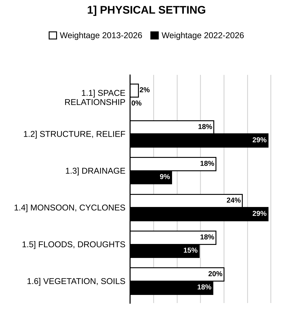
1.1] Space relationship of India with neighbouring countries
1 question
Mention the space relationship of India with neighbouring countries. (In about 150 words) [2016/10m/150w/1c]
1.2] Structure and relief; physiographic regions
20 questions
Briefly describe the origin, distribution and economic significance of Cuddapah and Dharwar rock systems of India. [2026/10m/1b]
Referring to the location and physical formation of karewas, highlight their economic significance. [2025/10m/1b]
Discuss the basis of various explanations for the formation of Shiwalik. [2024/10m/1b]
Describe the origin, distribution and economic significance of Gondwana system of rocks in India. [2023/10m/1b]
Explain the geological characteristics and ecological significance of the Eastern Ghats. [2023/10m/150w/5c]
Describe the structure and relief features of Deccan Plateau. [2021/15m/6c]
Distinguish the geographical aspects of North-Western lava plateau and Chotanagpur plateau of peninsular India. [2018/20m/2a]
Justify the inclusion of Meghalaya in Peninsular India and discuss its vegetation and soil types. [2017/15m/7c]
Explain the topographical and structural characteristics of the Siwalik Range. (150 words) [2013/10m/150w/1b]
Explain the structural characteristics of the Deccan plateau. [2012/30m/2a]
Karewa Deposits and their economic significance. [2011/15m/200w/5b]
Explain Himalayan Orogeny and illustrate how the process has affected the geomorphic characteristics of Macro divisions of Himalayas. [2010/60m/2]
Distinguish between the West and East coasts of India in terms of their evolution, present topography and drainage pattern. [2009/60m/3]
Explain the different views put forth about the origin of Himalayas and divide Himalayas into vertical divisions. [2007/60m/2]
Discuss the relief features of Indian Northern Plains. [2001/60m/2]
Give a brief account of the second-order regions of India’s Peninsular Plateau. [2001/20m/200w/5b]
Describe the structure and relief features of Peninsular India. [2000/60m/2]
Explain the rise of the Himalayan ranges. (Short note) [1999/20m/R1]
Discuss the origin and main geomorphic feature of Thar Desert of India. [1997/20m/200w/1a]
Draw a sketch-map in your answer book to delineate the main physiographic regions of India and provide a reasoned account of the relief and structure of the Himalayan region. [1995/60m/2]
1.3] Drainage system and watersheds
13 questions
Discuss the variations in nature of glaciers in India and the emerging issues due to climate change. [2024/15m/3b]
Describe the salient features of east-flowing rivers of India. [2021/15m/4b]
Present the salient features of West flowing rivers of India. [2019/10m/150w/5a]
Explain the changing river courses and their impacts on the riparian population in India with suitable examples. [2018/10m/150w/5b]
Drainage pattern in Peninsular India is a result of its geological structure and topography. Elaborate. [2017/15m/8b]
Explain the shifting of river courses and river capturing in the Himalayas. (In about 150 words) [2016/10m/150w/1b]
How is drainage pattern determined by the water divide? (150 words) [2014/10m/150w/1c]
Highlight the socio-economic and ecological roles of River Cauvery in its riverine tract. [2014/20m/3a]
Present a comparative analysis of the regimes of Himalayan and Peninsular rivers of India and examine their implications in the irrigation system of the country. [2011/60m/2]
Distinguish between the Himalayan and the peninsular drainage system. [2008/60m/2]
Highlight the salient differences between the Himalayan and the Peninsular drainage systems. [2003/60m/2]
Draw a sketch map of India showing major river basins. Examine the feasibility of the concept of river basins as a planning unit. [1997/60m/7]
Examine the origin and characteristics of the antecedent drainage system of the Himalayas. [1996/20m/200w/1a]

Preparing for Prelims too?
Our UPSC Prelims Topic-wise PYQ eBook covers every Prelims question with detailed explanations, so you can see exactly where UPSC asks from.
View the BookDownload Free Sample1.4] Mechanism of Indian monsoons and rainfall patterns; tropical cyclones and western disturbances
16 questions
The relationship between El Niño and the Indian monsoon is becoming complex under the conditions of global warming. Critically examine. [2026/20m/2a]
How are geographic factors influencing the distribution of high annual rainfall in certain parts of India? [2024/10m/150w/5a]
Critically examine the factors affecting the unpredictability of South-West Monsoon system in India. [2022/20m/2a]
Explain the impact of tropical cyclones and western disturbances on the climate of India. [2021/20m/6a]
Climate change has unsettled the rhythm of seasons. Comment with examples and empirical evidences. [2020/10m/1b]
Why is the Indian Monsoon erratic in nature? Explain. [2019/10m/1c]
Discuss the rainfall pattern and correlate it with spatial distribution of natural vegetation in India. [2019/15m/3c]
Explain the unusual intensity of dust storms and thunder storms across India in the pre-monsoon period of year 2018. [2018/10m/1b]
Give a reasoned account of unusual pattern of distribution of monsoonal rainfall in India in 2017. [2017/10m/1b]
Explain the pattern of winter rainfall in India. (In about 150 words) [2015/10m/150w/1c]
Discuss the mechanism of Indian Monsoon. (150 words) [2013/10m/150w/1c]
Give reasons as to why rainfall variability is a characteristic feature of India’s monsoons. [2009/30m/2b]
Give a critical reasoned account of the recent theories of origin of Indian Monsoon with special reference to jet stream theory. [2006/60m/2]
Explain the origin, mechanism and characteristics of Summer Monsoon in India. [2002/60m/2]
Elucidate the mechanism of the Indian Monsoon. [1999/60m/R5]
Explain the factors responsible for uneven distribution of rainfall in India. [1995/20m/200w/1a]
1.5] Floods and droughts; climatic regions
12 questions
Explain the factors that contribute to droughts in India with specific reference to food production, distribution and availability. Can Indian agricultural policies resolve the issue? [2025/20m/7a]
Discuss the problems of floods and their management with special reference to Indo-Gangetic Plain. [2023/15m/3b]
Appraise why drought is one of the most common climatic extremes in India. [2021/15m/2b]
Discuss the role of spatial pattern of rainfall and temperature in the delimitation of climatic regions of India especially with reference to Stamp’s climatic regionalization. (In about 250 words) [2016/20m/250w/2a]
Describe the flood-prone areas and their management problems in the Ganga Plains. (In about 200 words) [2016/15m/200w/2b]
Describe the salient climatological characteristics of Rayalaseema region. [2014/20m/4a]
Comment on the criteria of identifying Drought Prone Areas in India. (150 words) [2014/10m/150w/5d]
Discuss the role of spatial pattern of rainfall and temperature in the delimitation of climatic regions of India, specially with reference to Stamp’s climatic regionalization. [2012/30m/2b]
Comment on: Giving reasons, identify the chronic drought prone areas of India. [2009/20m/200w/5d]
Discuss the role of spatial pattern of rainfall and temperature in the delimitation of climatic regions of India, especially with reference to Stamp’s climatic regionalization. [2004/60m/2]
Explain the criteria used in the identification of drought-prone areas in India. [1996/20m/200w/1b]
Draw a sketch-map in your answer book to delineate the main climatic regions of India and discuss the important climatic characteristics of each region. [1996/60m/2]
1.6] Natural vegetation; soil types and their distributions
15 questions
Explain the vertical zonation of vegetation of the Himalayas. [2026/10m/1c]
Describe the geographical conditions necessary for the growth of mangrove forests in India. Explain their ecological and economic significance. [2026/10m/1d]
Soils of India, are clear reflections of the structure and process. Comment. [2022/15m/3c]
Discuss the economic significance of volcanic soils of India. [2021/10m/1c]
Soil types in India, classified on the basis of colour, possess specific chemical and mineral characteristics. Discuss. [2020/15m/2b]
Discuss the rainfall pattern and correlate it with spatial distribution of natural vegetation in India. [2019/15m/3c]
Justify the inclusion of Meghalaya in Peninsular India and discuss its vegetation and soil types. [2017/15m/7c]
Describe the distribution of black soils in India and their specific use for agriculture. (In about 200 words) [2016/15m/200w/4c]
How does natural vegetation affect the formation of in situ soils? (In about 150 words) [2015/10m/150w/1e]
Bring out the distribution of Laterite soils in India and their specific use for agriculture. [2014/20m/2a]
Discuss the spatial distribution of Natural Vegetation in India with the help of a sketched map. [2010/30m/3a]
Discuss the formation and their distribution of the major soil types of India. [2009/30m/2a]
Explain the sequence of vegetation zones of the Himalayas. [2001/20m/200w/5c]
Discuss the distribution and characteristics of the evergreen forest in India. [1996/20m/200w/1c]
Examine the origin and characteristics of the soils of the North Indian Plain. [1995/20m/200w/1b]

Strengthen your GS papers
Our UPSC Mains Topic-wise & Year-wise PYQ eBook (2013–2026) maps every GS question to the syllabus, so you know what UPSC asks and how often.
View the BookDownload Free Sample« Previous: Models, Theories and Laws in Human Geography | Next: Resources »
Back to: Geography Optional PYQs – Topic-wise | Also see: Geography Optional year-wise question papers
Last updated: 30 October 2026